The Falaj System in India
Majid Labbaf KhaneikiAssistant ProfessorUNESCO Chair on Aflaj Studies
.JPG)
Falaj is a gently sloping subterranean canal, which taps a water-bearing zone at a higher elevation than cultivated lands. In this article, my exploration is focused on a type of falaj that is called Iddi (Dawoodi) falaj in Oman, a hydraulic system that consists of a series of vertical shafts in the sloping ground, interconnected at the bottom by a tunnel with a gradient flatter than that of the ground. In Oman, the first shaft (mother well) is sunk, usually into an alluvial fan, to a level below the groundwater table. Shafts are sunk at intervals of around 10 to 50 meters in a line between the groundwater recharge zone and the irrigated land. From the air, the typical image of a falaj system resembles a line of anthills leading from the foothills across the desert to the greenery of an irrigated settlement. However, in Karnataka, India, I came across a different type of falaj which well reflects the environmental conditions of the region.
“There are running springs from every direction like the water of eternity…”
It is a translation of a Persian poem quoted by Sayyid Ali Tabataba to describe what Bidar was like at the time of the Bahmani dynasty. The city of Bidar is situated on the Deccan plateau in the northeastern part of Karnataka state in India. Water and city are interwoven everywhere in Bidar, and this relationship is manifested in every feature of this region even when you read the information board of a Sikh temple: “Guru Nanak Devji was born during the fifteen century…During his second tour to Deccan from Sultanpur, he reached Bidar via Rajashtan…The people of Bidar who came for his darshan requested him to bless them with sweet water as the water in Bidar was salty. Sri Guru Nanak Devji remembered God and touched the ground with his right foot, causing a spring of sweet water to gush from this place and permanently flowing from April 1512 on. The people of Bidar come here to take water for drinking …”.
It does not matter which one is true, the Sikh belief that reflects water scarcity or the contradicting Persian poem that brags about the abundance of springs in Bidar. What matters is the significance of water in the history and culture of this magnificent city.
In India, water has always been a subject on which the engineers could have exhibited their genius for such hydraulic structures as embankments, water towers, cisterns, canals, falaj, etc., and a possibility for the kings to flaunt their majesty through building splendid fountains, pools, waterfalls, and brooks. Water used to be the cornerstone of a civilization which had to deploy a great deal of ingenuity in adapting itself to the fickle climatic conditions of this region where monsoon pours down torrential rains and dry seasons scorch the land.
In the course of history, these people had to adjust to water fluctuation on the one hand and to live up to each other’s demand for water on the other. Even we may be tempted to say that the water challenge paved the way for Buddha to undergo Parivraja (renunciation) and step toward Nirvana. The river Rohini was shared by the states Sakyas and Koliyas to irrigate their farmlands, and a severe dispute broke out between the two states over this water. Buddha’s sate Sakyas waged war against Koliyas, but Buddha refused to participate in the war, instead, he embarked on his spiritual journey to avoid any engagement in such a bloody battle. Water has left its footprint even in a Buddhist meditation in India!
North of Karnataka including Bidar and Bijapur is overwhelmed by a rich water history, which is anchored in its environmental conditions. In Bidar, groundwater can be stored in a layer of laterite which varies in thickness from 10 to 30 meters. A layer of impermeable basalt underlies the layer of laterite, which creates a situation suitable for a shallow aquifer. The porous laterite can easily soak up the runoffs during rainy seasons but also loses its water easily during dry seasons. That is why the depth to groundwater level varies from 2.81 to 17.90 meters below the ground surface in May, and this number abruptly changes to between 0.40 and 13.09 in November.
This sharp fluctuation in the water table drove the inhabitants of this region to come up with many innovative techniques to better tackle the water problem. All these techniques revolve around the fact that water influx should be harnessed and stored during rainy seasons to be used during dry seasons when natural precipitation fails to meet the water demand. It is no exaggeration to say that Bidar is a big water museum which reflects a good example of human capability in adapting themselves to environmental conditions.
I conducted a research project on the falaj of Naubad, in Bidar in Karnataka, India, between 2014 and 2016. In this region, falaj system is locally called karez. The word Naubad reminds a Persian visitor like me of many places with the same name in Iran, which means “a place built newly”. I do not want to rehash the story of construction of Naubad by Bahmani dynasty and probable contribution of Persian qanat (falaj) masters to the karez which was built to supply the new town with required water.
It is likely that Mahmud Gavan the Bahmani minister who came from Iran with the memory of tens of thousands of Persian qanats came up with the idea of digging another qanat as a familiar solution to water shortage. We cannot rule out the possibility of Persian qanat masters invited by Bahmanis, but at least we can take it for granted that those Persians came across a quite different situation in Bidar from what they used to see in Iran. In Iran, they used to dig qanats mostly in alluvial fans tens of meters in thickness. Their qanat tunnel cut into thick sediments through which groundwater seeped into the tunnel and flowed down toward the qanat exit where the tunnel and sloped ground surface eventually intersected.
But here in Bidar I can imagine a Persian qanat master (muqqani) baffled by undulating small hills which did not resemble the Iranian huge mountains whose high peaks were encrusted by snow melting throughout summer and feeding hundreds of qanats down there. They toiled to cut into hard laterite underlain by basalt rather than dig through porous soil in their Iranian experience. That is why one can see many local elements incorporated into Persian qanat technique to make up a special version of qanat that I prefer to call it Bidari karez. Bidari karez exemplifies the perfect harmony of human with nature and a clever adaptation to the environmental conditions.
Karez system in Bidar is unique and has resulted from a systematic relationship between human and its environment. It cannot be completely ruled out that the early people of Bidar adopted the idea of qanat technology from Persians especially at the time of Bahmani dynasty who were on very friendly terms with Iranians. Even if we accept it, this idea has been tailored to the geographical and climatic conditions of Bidar by incorporating many local elements into the so called qanat technology. Therefore, this type of karez is specific to this region and is an intrinsic element of this cultural landscape. In a nutshell the main characteristics of karez in Bidar can be listed as follows:
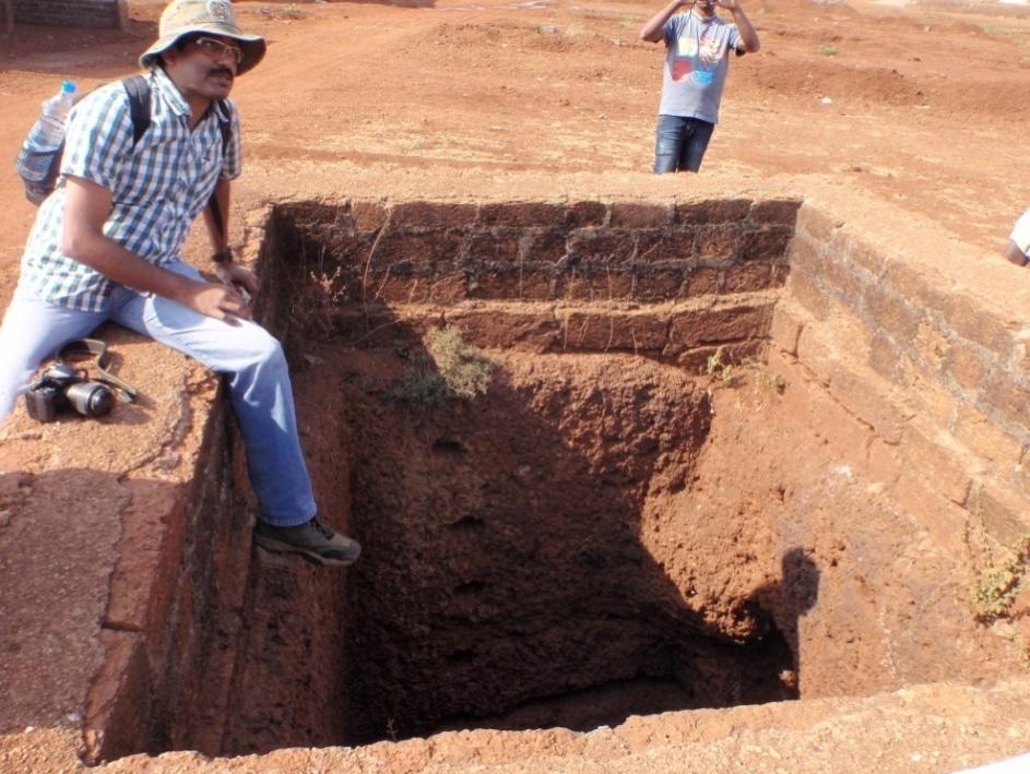
1- Karez and cistern combine as a unique structure. The wells have been dug in a relatively large size as well as below the level of karez tunnel in order to store water when karez water dwindles or temporarily dries up. That is why I used the word “Karezvoir” for this type of falaj, which means a hybrid of karez and water reservoir.
2- Tools and techniques used in karez construction were specific to Bidar whose conditions did not allow the workers to apply Persian or Omani tools. For example, a Persian windlass could not be installed for a square well with such large dimensions of 5 by 5 meters. Geological formations of the region also gave rise to a set of special tools and equipment.
3- Architectural value of Bidar karez system is unique. Laterite gave the early builders an opportunity to consider the aesthetic aspect of karez and deploy the architectural heritage of the region even in karez. Almost in every version of qanat, what the workers usually do is to devise an engineered tunnel to tap the aquifer. But in Bidar, they were not only concerned about the engineering aspect of karez construction, but also envisioned architectural possibilities by building beautiful stone walls, elaborate arches cut out of laterite, etc.
4- Gradient of Karez tunnel does not follow the surface slope, which results in direction of surface streams opposing that of karez flow.
5- The karez wells have been all dug square in shape. This shape helped them to find the right direction underground where the early workers wanted to dig a tunnel from one well to another. Also, this shape was suitable for mining and cutting out cubic stone blocks for other constructions.